
NOAA Coast Survey Archive about George Davidson
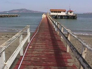
San Francisco Presidio Tide Station – Courtesy NOAA
In response to my blogpost about George Davidson , Albert “Skip” Theberge kindly shared some interesting information from the National Oceanic and Atmospheric Administration (NOAA) Archives. He has written a detailed history about San Francisco having the longest tidal record in the western hemisphere – over 150 years of data – and George Davidson’s role in the first Coast Survey work on the West Coast:
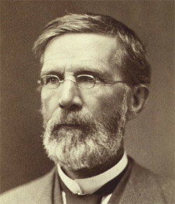
George Davidson Courtesy Wikipedia
“Because of immigration to the Oregon country, the Coast Survey had been making plans to survey the coast of Oregon Territory as early as 1846. In 1848, Congress authorized this work and the Coast Survey sent its first crews to the West Coast in 1849. Unfortunately, the gold rush was on; labor, transportation, and costs of supplies skyrocketed with an accompanying stoppage of field operations. One crew, under Assistant James Williams, was sent for the land operations and another, under Lieutenant William P. McArthur, USN, for the offshore hydrographic surveying operations. The Coast Survey Schooner EWING arrived in San Francisco after fighting its way around Cape Horn after a seven-month trip on August 1, 1849. The EWING was a topsail schooner 91 feet in length. For a variety of reasons including desertions and a mutiny, the EWING also was stymied in 1849 and retired with the land crew to the Hawaiian Islands for the winter of 1849-50 to obtain new crew members and to resupply at cheaper rates. Because of the above frustrations, Alexander Dallas Bache, Superintendent of the Coast Survey, decided that a crew of young energetic men with “reputation to make” and a desire to overcome all hardships should be sent to the West Coast in 1850. This group of four men was led by George Davidson, who would become the leader of the West Coast scientific community over the next half century. James Lawson, A. M. Harrison, and John Rockwell comprised the remainder. Davidson, Lawson, and Rockwell sailed from the East Coast on May 5 on the steamer PHILADELPHIA for Panama. They landed at Chagres, hired native Indians for traveling by canoe to the head of the Chagres River, and then joined a mule train to go the rest of the way to the city of Panama.
… Of the four young men who came west in 1850, George Davidson (1825-1911) and James Lawson (1828 – 1893) would remain on the West Coast for most of the remainder of their lives. Davidson made his home in San Francisco and was by far the most well-known of the group as he was considered California’s most prominent scientist for many years and had many geographic features named after him including Mount Davidson in San Francisco and Davidson Seamount to the southwest of Monterey.”
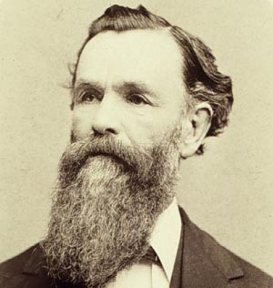
Jame S. Lawson – Courtesy www.history.noaa.gov
James Lawson’s autobiographical detailed memoir is also archived at NOAA and provides an amazing account of what it was like to attempt to map the west coast with George Davidson from 1850 onward. “We first held forth at the “St. Francis” Hotel, where Mr. Davidson has secured rooms; this was then the “nobby” hotel of the town. Just before turning the corner from Dupont St. into Clay St. I suddenly came face to face with my old friend O.P. Sutton, and never shall I forget the look of astonishment with which he greeted me. Such surprises became so common in those days, however, that the effect was but momentary. A couple of days’ experience at the St. Francis amply demonstrated the fact that such grand prices of living ($7.00 per diem) were not in keeping with our own pay, or with the purse and projects of Venerable Master (U.S.). We took a room in a small wooden building on the opposite corner from the St. Francis, and got our meals where we chose.” …
“On July 12th we started on the Active, and in about 5 or 6 days arrived at Nee-ah Bay, 6 miles East of Cape Flattery, in the Straits of Juan de Fuca. The cape was really Mr. Davidson’s objective point, but the Bay presented the best location for camping, and from there all operations could be conducted. The tribe of Indians–Mah-Kah (See how Mr. J.G. Swan spells this name, and adopt his orthography) was not then particularly friendly towards the whites, and before going into camp it was deemed best to have an understanding with them. For this purpose a hy-as wah-wah (big talk) was appointed to take place with the Chief Clis-seet and his tribe at the Warm House (summer village) between Nee-ah Bay and Cape F., the next day.”
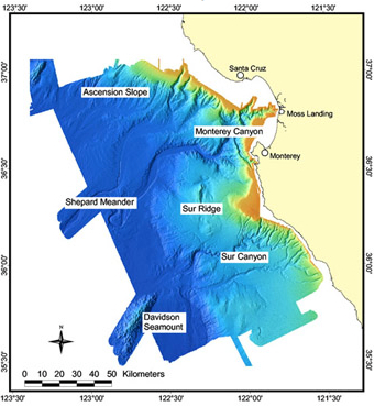
Courtesy http://www3.mbari.org/expeditions/Davidson/index.htm
A Davidson Seamount map was produced by NOAA as a special edition for the 100th anniversary of the U.S. Board on Geographic Names. Located southwest of Monterey, it is nearly 8000 feet high – much taller than Mt. Davidson in San Francisco – yet remains submerged over 4000 feet beneath the ocean’s surface. According to information posted by the Monterey Aquarium, “seamounts—remnants of former volcanoes—are interesting not only for their geology but also for their biology. The water above seamounts are productive feeding grounds for a wide variety of fishes, marine mammals, and seabirds. The rocky surfaces of seamounts serve as habitat islands for deep-sea animals.” They have posted a video of the Davidson Seamount.
Posted July 20, 2017